
Throwback : Malnad Magic in Monsoon Surge – Part 1
Prologue
Amidst the avid watchers of the strongest Global Monsoon – the South West Monsoon, it is no secret that the epitome of Monsoon activity in the Western Ghats and Coast can classically occur as a recipe like this – The interplay of a tropical wave like MJO staying enhanced in North Indian Ocean supporting the formation of a typical Monsoon System in Bay and thus creating an offshore trough in Arabian Sea. This then causing moisture drag across the Peninsula, bringing high rainfall to the West Coast and Western Ghats. This epitome phase is the Monsoon Surge which can bring 100s of cms rain during the surge period to many places. Sometimes, when the surge is too strong, it tends to become a recipe for disaster cascading into floods.
There was a short lull in the Monsoon of SWM 2018 after having a 3 day early onset in Indian Mainland on May 29th 2018. Although, the recipe for an active Monsoon surge from June 06th in the West Coast and Ghats, was getting cooked.
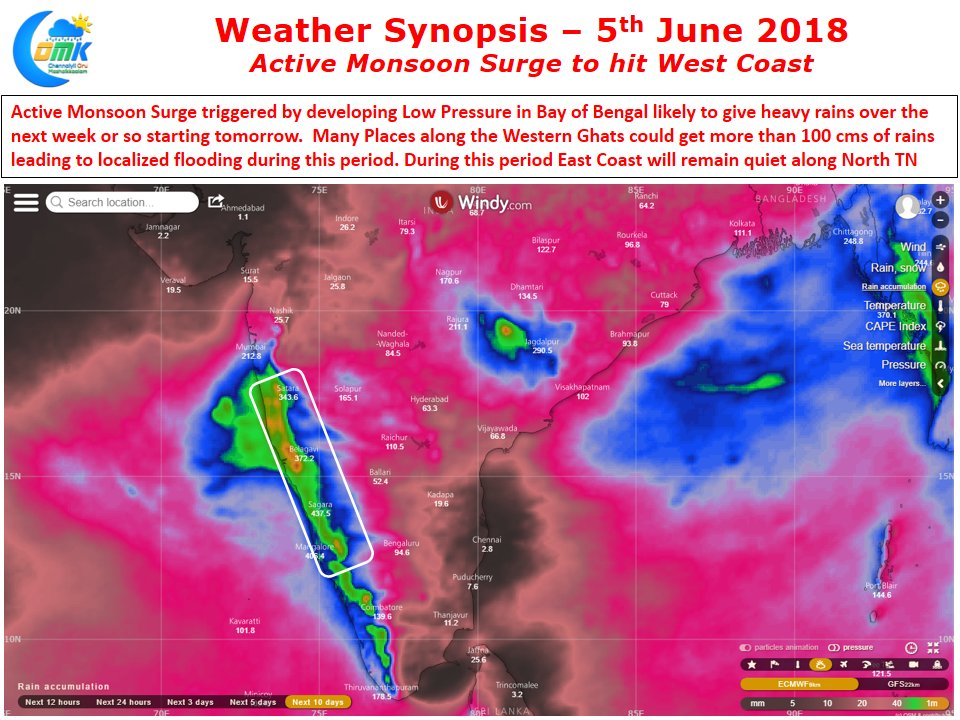
We were watching the Surge brewing up, especially, inspired by COMK Weather Blog post dated June 05th 2018 – “Active Monsoon Surge To Hit West Coast”
Friday, June 08, 2018
A typical working Friday before a normal weekend kicks in. Halfway through the day, at 1230pm, friend from Chennai calls and asks what is the plan for the weekend. Knowing him well and knowing what’s going to be in store, the eagerness to witness the Monsoon Surge skyrocketed. An hour later, we had decided on Malenadu, the homestay and that the start from Chennai will be by 9pm, the same day.
Saturday, June 09, 2018
In the wee hours, I got picked up in Bangalore and then we continued onto NH4. At dawn, we were at Hiriyur, turning off towards Malenadu onto 2 laned territory from now on, and heading Westwards.

Not only the sky-scenes, even the landscapes were lively!

We got into the first rain bands near Bhadra Dam, and from here on, the next 36 hours way going to be a journey with the rains all along

The stretch from Bhadra Dam to Muttinakoppa is partly through State forest area but also dotted with green fields around the villages

We crossed Tunga @ Muduba Bridge, the brown swelling river shows the effect of the Surge in catchment areas

As we crossed Tunga, I was discussing with my travel companions on how these waters would reach Bay of Bengal finally!
Tunga originates from Gangamoola in Kudhremuka National Park (which is also the origin point for Bhadra and Netravathi). It meanders across places in Malenadu like Sringeri, Hariharapura, Thirthahalli, Gajanur Dam, Shimoga and then merges with Bhadra to form Tungabhadra at Kudli, after Shimoga. Tungabhadra then flows in N/NE/E direction passing by Harihar, TB Dam, Hospet, Hampi, Siruguppa, Mantralayam, Kurnool and joins the mighty Krishna River at the Srisailam Reservoir. Krishna river similarly starts near Jor (another Monsoon Giant), Mahabaleshwar and has a much longer journey to Srisailam. From Srisailam, Krishna then flows via Nagarjuna Sagar, Vijaywada and joins Bay at Hamsaladeevi. Such a spectacle!
As we finished discussing this, we stopped at Thirthahalli for breakfast – the first proper break after an overnight drive from Chennai. The homestay we had booked was located in Koppa – about 25kms and less than 1 hour from here, but we took aDetour route to experience the Monsoon giant areas. It was 125kms drive through Panchagangavalli rivers catchment areas, down to the plains via Hulikal Ghat and back up to Malnad via Agumbe Ghat. 7+ hours from Thirthahalli to Koppa.
We were heading to drive through a road that cuts right through the Reservoir of the Varahi catchment. This road appears when the reservoir levels are low, typically at the end of Summer, possibly because the previous year’s rain weren’t in excess category. The road disappears under water usually by June mid-end, based on the surge quantum here.

This road reduces the distance between the 2 points by more than half. Although due to it remaining under water for most parts of the year, even the approach road is not maintained.
When the reservoir opened up completely after traversing 15 minutes of thickly infested vegetation, it was clear that the water levels are low and the roads would be open

One of the two causeways in the reservoir route, a week later this must have been under water.

Just 10 minutes of staying out (because it was only drizzling), we had to rush back into the Car, it started pouring, even umbrellas couldn’t withstand, we were drenched in the process of running to the car – typical Monsoon feels. It became dark, we were right inside one rain band. It kept pounding for the next 15 minutes, after which it moved away, giving a short break before the next band came in – classical SWM style!

As the rain band cleared out, we proceeded towards the other end of the reservoir, hoping that the causeway there would be open too.

Water water everywhere! That was the sight

The is the other side of the Reservoir. While we were going to exit the reservoir, we were discussing about where these waters reach.
It is mysterious why there is a misconception that only Naramada and Tapi are west flowing rivers, that is how we were taught in School. There are 1000s of rivers which flow Westward, mostly from Western Ghats catchment to the Arabian Sea, be it Gujarat, Maharashtra, Goa, Karnataka, Kerala or Tamil Nadu.
And here, we are discussing about Varahi, since we were on the Varahi catchment reservoir, locally also known as Mani Dam. This catchment collects rainfall from Western Ghats areas between Hulikal – Agumbe and other nearby places. The part of the reservoir which we crossed is only one edge. On the other end is the dam with the Masthikatte Hydel Plant which generates small amount of energy, after which Varahi river flows through Kunchikal Falls and jumps down to the plains and at Hosangadi in the plains is the underground Varahi Powerhouse which generates much more energy.
When Varahi joins Arabian Sea near Kundapura, it joins with Chakra, Kedaka, Kubja, Sowparnika rivers – which is known as Panchagangavali.

SWM Giants – Hulikal, Agumbe, Yadur and Masthikatte from this region compete with each other on who scores the highest at the end of season. These areas receive at least 5000+mm rainfall during SWM many times. They are amongst the leagues of the highest rainfall places in Karnataka, along with Talacauvery, Amangaon, Kogar.etc

After crossing Yadur and Masthikatte (all SWM giants) and before entering Hulikal Ghat, we cross the northernmost edge of the Varahi Reservoir, which is also fed in by Savehaklu balancing reservoir.

After Masthikatte, we took aDetour to the Savehaklu Reservoir. This acts as a balancing reservoir, feeding waters to Varahi as well as Chakra rivers. Both Savehaklu and Chakra were initially constructed as balancing reservoirs for the mighty Linganamakki reservoir.
Here is a picture from the Savehaklu Dam top, it had lesser water at this end

It was 1pm (3 hours since we started from Thirthahalli) when we began the descent down the Hulikal Ghat towards the plains. The rain bands had disappeared after we exited Masthikatte and took aDetour to Savehaklu, but once we were onto the Hulikal Ghat, it was a spectacular sight to see the next bands coming in from the Coast and pounding the plains!

Hulikal Ghat!

We stopped at the “Hulikal Falls” which had clear water. There was an urge to take a dip, but luckily it isn’t such a falls as it is not easily reachable.
This take-a-dip-in-the-roadside-waterfall mania has come from easily reachable roadside waterfalls in Maharastra Ghats.

Once we hit the plains of Siddapura, we did not want to go more West, as the rain bands we saw from the Ghats would’ve come more closer now, hence we wanted to stay as close as possible to the Ghats, to experience maximum from those rain clouds.
Hence, we took aDetour from Siddapura to Someshwara (Agumbe foothills) via interiors like Amasebailu, Shedimane and Madamakki.

One such vistas from the interior route overlooking the Ghats

The rains in the interior route was fabulous, it was like tanks of water being poured over the vehicle again and again. It was the best surge band of the drive. Rains gradually reduced as we neared Someshwara

At 230pm, we were climbing up the Agumbe Ghat, raining continuously.

We stopped a few minutes atop Agumbe Ghat, as we entered back into Malenadu, typical Agumbe vistas – foggy + rainy!

We reached the homestay in Koppa at 330pm, it was a quick drive from Agumbe, raining on and off as we moved East.
The homestay owner was courteous to keep the Lunch still hot, although she expected us to check-in at 1pm. The Malnad Lunch was delicious, and we were too hungry too. Shavige with coconut milk was the highlight.

We spent rest of the evening lazing around the beautiful homestay, midst the plantations, while the rains continued to sing its Surge song! We called it a day early after dinner, to rest before another long drive day. Sleep took over as we reminisced the vistas through the day, as the rains poured through the night.
This was how the Google timeline looked like from Point A – Thirthahalli to Point B – Koppa, typically aDetour to experience the Monsoon Surge!

When we looked back at the KSNDMC Karnataka Rainfall report ending 10th June 2018 830am, it was affirmative that – the areas we drove to indeed received Heavy Rains that day!

*dark blue category is actually Very Heavy Rains >=124.4mm – wrongly printed in the above report legend
Highest rainfall in Shimoga district for the day was at Saluru with 179mm, which is very close to the Varahi catchment areas that we drove through. Similarly, highest rainfall in Udupi district for the day was at Madamakki with 135mm, we passed right through Madamakki where we faced heaviest rains of the drive that day. Although, these numbers were just half of what we saw on Day2!

Thanks for reading so far, hope you enjoyed the Monsoon virtually through the pictures. Stay tuned for Part 2


